 Watershed
Assessment
(Streams, Rivers and Lakes) Watershed
Assessment
(Streams, Rivers and Lakes)
Watershed
assessments, including biomonitoring, are an evaluation of the condition
of a waterbody using physical, chemical, and biological measurements
collected from fresh surface waters.
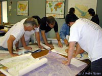
GIS Mapping Services
GIS (a geographic information system) provides a visual method to
communicate, understand, and interpret data. WAA's reports can include
watershed delineation and GIS mapping services using ArcGIS 9.2
that provides a visual understanding of the data results. Maps of
assessment locations are often included in our reports. Examples
of watershed maps can be found on our experience
page. WAA can also provide a geodatabase
of the data for the client.
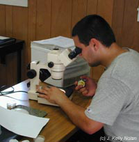 Taxonomy
Services Taxonomy
Services
Taxonomy is
the classification of organisms in an order system. In our case
the organisms are benthic macroinvertebrates collected from freshwater
systems which include insects, crustaceans, clams, snails, and worms.
 Technical
Training Technical
Training
- Our
training workshops are designed to introduce participants to the
standard methods of chemical, physical, and biological stream
monitoring and assessment, and to provide comprehensive aquatic
benthic macroinvertebrate taxonomy training. For a list of workshops
being organized and/or taught by WAA click here.

MS4
Education and Monitoring
The Environmental
Protection Agency Municipal Separate Storm Sewer Systems (MS4) water
regulations include requirements that an MS4 community fulfill.
WAA's services and training programs can address many of the MS4
requirements. Find out more.
Top
|

